Summer School on Modelling Tools for Sustainable Development
Three-week intensive training on data management with FOSS GIS to support geospatial electrification models for government officials, utility analysts and academic researchers
Description
The summer school entailed three-week intensive training on data management with FOSS GIS to support geospatial electrification models for government officials, utility analysts and academic researchers. The training focused on all the steps required to develop an SDI. Kartoza developed and presented all the GIS materials.

Services Provided
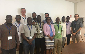
The third annual Summer School for Summer School on Modelling for Sustainable Development (SDSS 2019) was held under the capacity building component of the Global Program for Geospatial Electrification Planning Scale Up(P164156) which is being implemented at the global level under the ESMAP Sustainable Energy for All Technical Assistance Facility (S-TAP), supporting client countries in achieving universal access to modern energy services by 2030. The 3-week intensive training was jointly organized by ESMAP, the World Bank, United Nations Economic Commission for Africa (UNECA), UNDP, UNDESA, DFID, Abdus Salam International Centre for Theoretical Physics (ICTP), KTH and the OpTIMUS Community.
Two training tracks were offered to cover key aspects of sustainable electrification planning: modelling and data management (presented by Kartoza). These tracks were designed to address the capacity gaps identified by World Bank Group operational teams, and lessons learned from previous capacity-building efforts.
Track 1 - Geospatial electrification modelling through OnSSET: provided an overview of basic concepts of geospatial analysis and the benefits of geospatial planning for the achievement of universal access as well as utility management and power sector planning. Subsequently, the students were introduced to different modelling tools (with a focus on modelling options with and without MV lines). These tools enable the identification of country-based investments financing requirements, integrating grid and off-grid solutions and the results in turn inform national electrification efforts. The first track mainly targeted energy planners and utility representatives.
Track 2 - Geospatial data and software management (presented by Kartoza): provided training in many aspects of geospatial data management and analysis, design and management of a geospatial database, use of geospatial software, analytics, data collection and management for use across the energy sector. Participants were given an overview of open-source desktop, mobile and cloud-based tools for managing and developing a sustainable electrification planning system. The second track targeted energy planners, utility representatives and IT/ICT specialists, preferably with background in GIS.
Although the two tracks aimed to empower different practitioners, some sessions were jointly attended to ensure the adequate empowerment of the trainees.
During the last three days of the training, the attendees had the opportunity to present their results to the class and get feedback from representatives of the training partner institutions. This offered participants the opportunity to interact and exchange experiences from their respective fields and countries.
Completed: 2019-07-31


